
Integration of Building Age into Flood Hazard Mapping: A Case Study of Al Ain City, United Arab Emirates
Wed, 8 January 2025
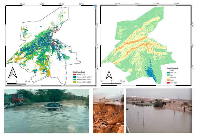
Accurate and timely information on building age is essential for mitigating the impacts of natural disasters such as earthquakes and floods. Traditional methods for collecting these data are often inefficient and costly. The research “Integration of Building Age into Flood Hazard Mapping: A Case Study of Al Ain City, United Arab Emirates”, led by Dr. Tareefa Alsumaiti and Prof. Mohamed Yagoub from Geography and Urban Sustainability Department , leverages remote sensing and machine learning to classify building age and integrate this information into a comprehensive flood hazard map for Al Ain City.
By combining building age with elevation, topography, land use, population density, and other factors, a flood hazard map that effectively identifies high-risk areas was generated. The results show that a significant portion of the city is has low potential for flooding (61%), while others face moderate (32%), high, or very high flood hazards. The study provides crucial information for informed decision-making regarding future urban planning, disaster management, and development strategies in Al Ain City. By identifying vulnerable buildings in advance, it supports efforts to reduce disaster risks, protect lives, and optimize resource allocation.
Do you find this content helpful?
عفوا
لايوجد محتوى عربي لهذه الصفحة
عفوا
يوجد مشكلة في الصفحة التي تحاول الوصول إليها